
The Mesh Navigation bundle provides software for efficient robot navigation on 2D manifolds, which are represented in 3D as triangle meshes. It enables safe navigation in various complex outdoor environments by using a modularly extensible layered mesh map. Layers can be loaded as plugins representing specific geometric or semantic metrics of the terrain. This allows the incorporation of obstacles in these complex outdoor environments into path and motion motion planning. The layered Mesh Map is integrated with Move Base Flex (MBF), which provides a universal ROS action interface for path planning, motion control, and for recovery behaviors. We also provide additional planner and controller plugins that run on the layered mesh map.

- Publications
- Installation
- Usage Examples and Demos
- Software Stack
- Mesh Map
- Planners
- Controllers
- Simulation
- Maintain and Contribute
- Build Status
Please reference the following papers when using the navigation stack in your scientific work.
@inproceedings{puetz21cvp,
author = {Pütz, Sebastian and Wiemann, Thomas and Kleine Piening, Malte and Hertzberg, Joachim},
title = {Continuous Shortest Path Vector Field Navigation on 3D Triangular Meshes for Mobile Robots},
booktitle = {2021 IEEE International Conference on Robotics and Automation (ICRA)},
year = 2021,
url = {https://github.com/uos/mesh_navigation},
note = {Software available at \url{https://github.com/uos/mesh_navigation}}
}
@inproceedings{puetz18mbf,
author = {Sebastian Pütz and Jorge Santos Simón and Joachim Hertzberg},
title = {{Move Base Flex}: A Highly Flexible Navigation Framework for Mobile Robots},
booktitle = {2018 IEEE/RSJ International Conference on Intelligent Robots and Systems (IROS)},
year = 2018,
month = {October},
url = {https://github.com/magazino/move_base_flex},
note = {Software available at \url{https://github.com/magazino/move_base_flex}}
}
This is the active ROS2 branch of this repository, which targets humble.
If your are looking for the old ROS1 version, checkout the noetic branch.
- Prerequisite: A working ROS 2 installation
- Go into a ROS 2 workspace's source directory
cd $YOUR_ROS_WS/src. - Clone the repo
git clone git@github.com:naturerobots/mesh_navigation.git - Get the tutorial's ROS 2 dependencies
- Clone source dependencies: Run
vcs import --input mesh_navigation/source_dependencies.yamlin your ROS 2 workspace source directory. - Get packaged dependencies: Run
rosdep install --from-paths . --ignore-src -r -yfrom within your ROS 2 workspace source directory.
- Clone source dependencies: Run
- Build: Go to workspace root
cd $YOUR_ROS_WSand runcolcon build --packages-up-to mesh_navigation.
Use the pluto_robot package for example HDF5 map datasets, Gazebo simulations, and example configurations.
Recommended entrypoint for new users: Check out the mesh_navigation_tutorials for a ready-to-use mesh navigation stack. Complete with simulated environment, rviz config, mesh nav config, etc.
See the pluto_robot bundle for example configurations of the mesh navigatoin stack and usage (ROS 1).
In the following demo videos we used the developed VFP, i.e., the wavefront_propagatn_planner. It will be renamed soon to vector_field_planner.
| Dataset and Description | Demo Video |
|---|---|
| Botanical Garden of Osnabrück University | 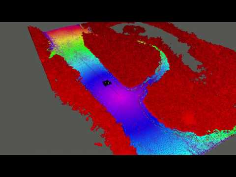 |
| Stone Quarry in the Forest Brockum | 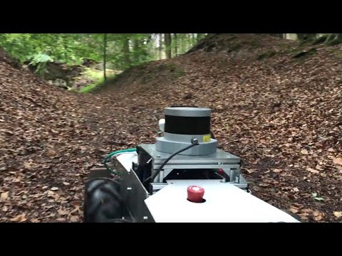 |
| Colored Point Cloud | Height Diff Layer | RGB Vertex Colors |
|---|---|---|
 |  |  |
This mesh_navigation stack provides a navigation server for Move Base Flex (MBF). It provides a couple of configuration files and launch files to start the navigation server with the configured layer plugins for the layered mesh map, and the configured planners and controller to perform path planning and motion control in 3D (or more specifically on 2D-manifold).
The package structure is as follows:
mesh_navigationThe corresponding ROS meta package.mbf_mesh_corecontains the plugin interfaces derived from the abstract MBF plugin interfaces to initialize planner and controller plugins with onemesh_mapinstance. It provides the following three interfaces:- MeshPlanner -
mbf_mesh_core/mesh_planner.h - MeshController -
mbf_mesh_core/mesh_controller.h - MeshRecovery -
mbf_mesh_core/mesh_recovery.h
- MeshPlanner -
mbf_mesh_navcontains the mesh navigation server which is built on top of the abstract MBF navigation server. It uses the plugin interfaces inmbf_mesh_coreto load and initialize plugins of the types described above.mesh_mapcontains an implementation of a mesh map representation building on top of the mesh data structures in lvr2. This package provides a layered mesh map implementation. Layers can be loaded as plugins to allow a highly configurable 3D navigation stack for robots traversing on the ground in outdoor and rough terrain.mesh_layersThe package provides a couple of mesh layers to compute the trafficability of the terrain. Furthermore, these plugins have access to the HDF5 map file and can load and store layer information. The mesh layers can be configured for the robots abilities and needs. Currently we provide the following layer plugins:- HeightDiffLayer -
mesh_layers/HeightDiffLayer - RoughnessLayer -
mesh_layers/RoughnessLayer - SteepnessLayer -
mesh_layers/SteepnessLayer - RidgeLayer -
mesh_layer/RidgeLayer - InflationLayer -
mesh_layers/InflationLayer
- HeightDiffLayer -
dijkstra_mesh_plannercontains a mesh planner plugin providing a path planning method based on Dijkstra's algorithm. It plans by using the edges of the mesh map. The propagation start a the goal pose, thus a path from every accessed vertex to the goal pose can be computed. This leads to a sub-optimal potential field, which highly depends on the mesh structure.cvp_mesh_plannercontains a Fast Marching Method (FMM) wave front path planner to take the 2D-manifold into account. This planner is able to plan over the surface, due to that it results in shorter paths than thedijkstra_mesh_planner, since it is not restricted to the edges or topology of the mesh. A comparison is shown below. Please refer to the paperContinuous Shortest Path Vector Field Navigation on 3D Triangular Meshes for Mobile Robotswhich is stated above.mesh_clientIs an experimental package to additionally load navigation meshes from a server.
The following table gives an overview of all currently implemented layer plugins available in the stack and the corresponding types to specify for usage in the mesh map configuration. An example mesh map configuration is shown below.
| Layer | Plugin Type Specifier | Description of Cost Computation | Example Image |
|---|---|---|---|
| HeightDiffLayer | mesh_layers/HeightDiffLayer | local radius based height differences |  |
| RoughnessLayer | mesh_layers/RoughnessLayer | local radius based normal fluctuation |  |
| SteepnessLayer | mesh_layers/SteepnessLayer | arccos of the normal's z coordinate |  |
| RidgeLayer | mesh_layer/RidgeLayer | local radius based distance along normal |  |
| InflationLayer | mesh_layers/InflationLayer | by distance to a lethal vertex |  |
Currently the following planners are available:
 - name: 'dijkstra_mesh_planner'
type: 'dijkstra_mesh_planner/DijkstraMeshPlanner'
 - name: 'cvp_mesh_planner'
type: 'cvp_mesh_planner/CVPMeshPlanner'
 - name: 'mmp_planner'
type: 'mmp_planner/MMPPlanner'
The planners are compared to each other.
| Vector Field Planner | Dijkstra Mesh Planner | ROS Global Planner on 2.5D DEM |
|---|---|---|
 |  |  |
If you want to test the mesh navigation stack with Pluto please use the simulation setup and the corresponding launch files below for the respective outdoor or rough terrain environment. The mesh tools have to be installed. We developed the Mesh Tools as a package consisting of message definitions, RViz plugins and tools, as well as a persistence layer to store such maps. These tools make the benefits of annotated triangle maps available in ROS and allow to publish, edit and inspect such maps within the existing ROS software stack.
For the necessary localization of the robot relative to the mesh, we recommend using RMCL: https://github.com/uos/rmcl. We presented the combination of both software packages at ROSCon 2023:

Maintainers:
Author: Sebastian Pütz
We are happy to receive improvements to the mesh navigation stack. Just open an issue. PRs welcome!
| ROS Distro | GitHub CI | Develop | Documentation | Source Deb | Binary Deb |
|---|---|---|---|---|---|
| Humble |  | N/A | N/A | N/A | N/A |
| Noetic |  |