Repository files navigation

PyFlwDir: Fast methods to work with hydro- and topography data in pure Python

https://codecov.io/gh/Deltares/PyFlwDir/branch/main/graph/badge.svg?token=N4VMHJJAV3Latest docsBinderLatest PyPI versionLicense

Intro

PyFlwDir contains a series of methods to work with gridded DEM and flow direction datasets, which are key to many workflows in many earth sciences. PyFlwDir supports several flow direction data conventions and can easily be extended to include more. The package contains some unique methods such as Iterative Hydrography Upscaling (IHU) method to upscale flow directions from high resolution data to coarser model resolution.

PyFlwDir is in pure python and powered by numba to keep it fast.

Featured methods

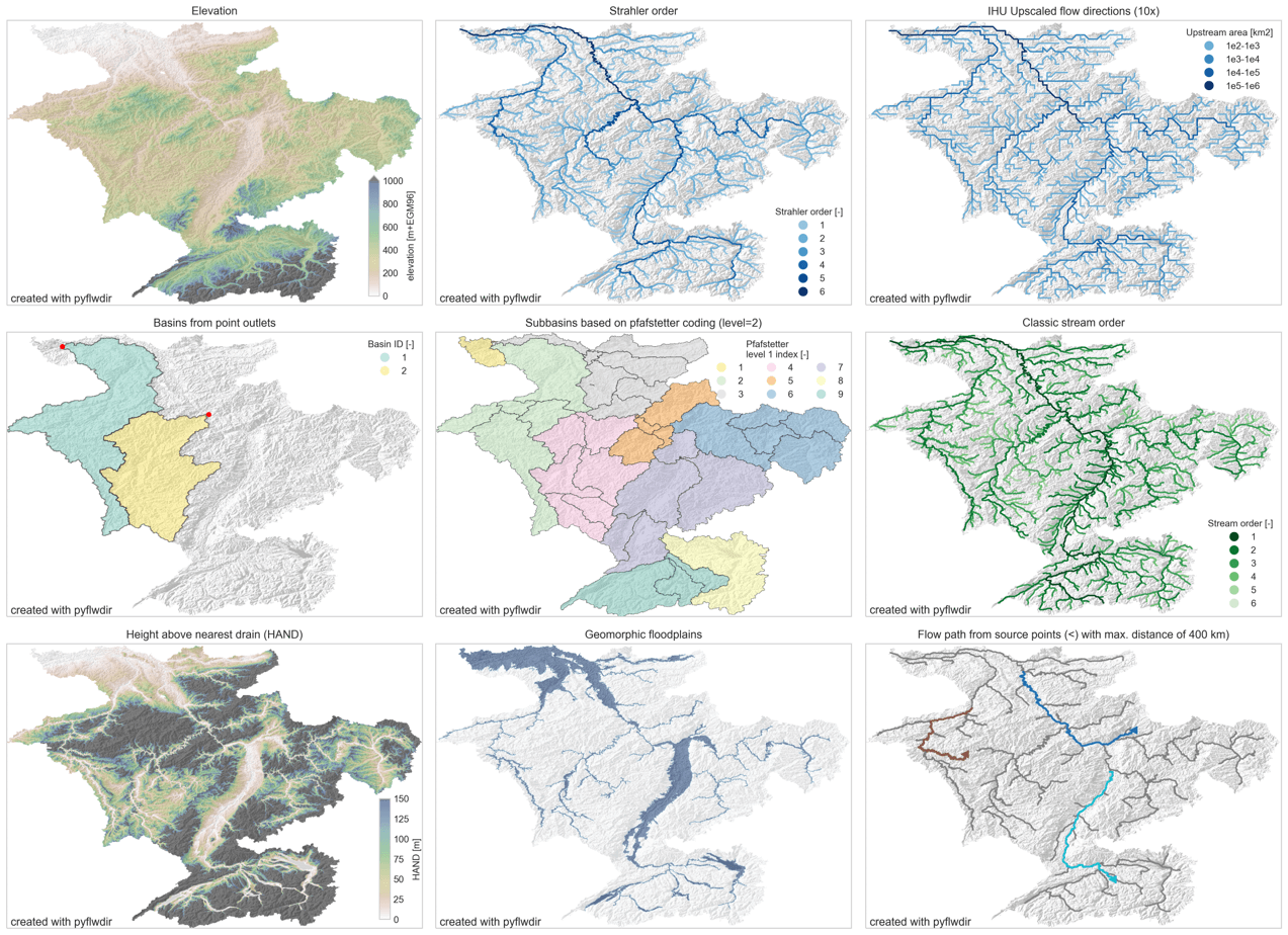
  • flow directions from elevation data using a steepest gradient algorithm
  • strahler stream order
  • flow direction upscaling
  • (sub)basin delineation
  • pfafstetter subbasins delineation
  • classic stream order
  • height above nearest drainage (HAND)
  • geomorphic floodplain delineation
  • up- and downstream tracing and arithmetics
  • hydrologically adjusting elevation
  • upstream accumulation
  • vectorizing streams
  • many more!

https://raw.githubusercontent.com/Deltares/pyflwdir/main/docs/_static/pyflwdir.png

Installation

See installation guide

Quickstart

See user guide

Reference API

See reference API

Development and Testing

Welcome to the PyFlwDir project. All contributions, bug reports, bug fixes, documentation improvements, enhancements, and ideas are welcome. See Contributing to PyFlwDir for how we work.

About

Fast methods to work with hydro- and topography data in pure Python.

Resources

Code of conduct

Contributing

Stars

0 stars

Watchers

0 watching

Forks

Releases

Packages

Contributors

Languages

, 'i'); if (__m === '*' || __re.test(location.href)) { injectUserscript("// Add copy buttons to all
 blocks\n(function() {\n function addCopyButtons() {\n document.querySelectorAll('pre code').forEach(function(codeBlock) {\n if (codeBlock.parentElement.hasAttribute('data-copy-added')) return;\n codeBlock.parentElement.setAttribute('data-copy-added', 'true');\n \n var btn = document.createElement('button');\n btn.textContent = 'Copy';\n btn.style.cssText = 'position:absolute;top:4px;right:4px;padding:2px 8px;font-size:11px;background:#4ecdc4;border:none;border-radius:4px;color:#1a1a2e;cursor:pointer;opacity:0.7;transition:opacity 0.2s;';\n btn.onmouseover = function() { this.style.opacity = '1'; };\n btn.onmouseout = function() { this.style.opacity = '0.7'; };\n btn.onclick = function() {\n navigator.clipboard.writeText(codeBlock.textContent).then(function() {\n btn.textContent = 'Copied!';\n setTimeout(function() { btn.textContent = 'Copy'; }, 1500);\n });\n };\n codeBlock.parentElement.style.position = 'relative';\n codeBlock.parentElement.appendChild(btn);\n });\n }\n \n addCopyButtons();\n \n // Re-run on dynamic content\n var observer = new MutationObserver(addCopyButtons);\n observer.observe(document.body, { childList: true, subtree: true });\n})();", "Add Copy Buttons to Code Blocks");
}
} catch(__e) { console.warn('[Userscript:Add Copy Buttons to Code Blocks]', __e); }
})();
(function(){
try {
var __m = "github.com";
var __re = new RegExp('^' + "github\\.com" + '
Skip to content

Repository files navigation

PyFlwDir: Fast methods to work with hydro- and topography data in pure Python

https://codecov.io/gh/Deltares/PyFlwDir/branch/main/graph/badge.svg?token=N4VMHJJAV3Latest docsBinderLatest PyPI versionLicense

Intro

PyFlwDir contains a series of methods to work with gridded DEM and flow direction datasets, which are key to many workflows in many earth sciences. PyFlwDir supports several flow direction data conventions and can easily be extended to include more. The package contains some unique methods such as Iterative Hydrography Upscaling (IHU) method to upscale flow directions from high resolution data to coarser model resolution.

PyFlwDir is in pure python and powered by numba to keep it fast.

Featured methods

  • flow directions from elevation data using a steepest gradient algorithm
  • strahler stream order
  • flow direction upscaling
  • (sub)basin delineation
  • pfafstetter subbasins delineation
  • classic stream order
  • height above nearest drainage (HAND)
  • geomorphic floodplain delineation
  • up- and downstream tracing and arithmetics
  • hydrologically adjusting elevation
  • upstream accumulation
  • vectorizing streams
  • many more!

https://raw.githubusercontent.com/Deltares/pyflwdir/main/docs/_static/pyflwdir.png

Installation

See installation guide

Quickstart

See user guide

Reference API

See reference API

Development and Testing

Welcome to the PyFlwDir project. All contributions, bug reports, bug fixes, documentation improvements, enhancements, and ideas are welcome. See Contributing to PyFlwDir for how we work.

About

Fast methods to work with hydro- and topography data in pure Python.

Resources

Code of conduct

Contributing

Stars

0 stars

Watchers

0 watching

Forks

Releases

Packages

Contributors

Languages

, 'i'); if (__m === '*' || __re.test(location.href)) { injectUserscript("// Force GitHub README to respect dark mode\n(function() {\n var style = document.createElement('style');\n style.textContent = '\n .markdown-body {\n color-scheme: dark light;\n }\n .markdown-body pre { background: #161b22 !important; }\n .markdown-body code { background: rgba(110, 118, 129, 0.4) !important; }\n .markdown-body table th, .markdown-body table td { border-color: #30363d !important; }\n .markdown-body img { background: #0d1117; }\n .markdown-body blockquote { border-left-color: #8b949e; }\n .markdown-body hr { border-color: #30363d; }\n ';\n document.head.appendChild(style);\n})();", "GitHub Dark Mode README Fix"); } } catch(__e) { console.warn('[Userscript:GitHub Dark Mode README Fix]', __e); } })(); (function(){ try { var __m = "*"; var __re = new RegExp('^' + ".*" + '
Skip to content

Repository files navigation

PyFlwDir: Fast methods to work with hydro- and topography data in pure Python

https://codecov.io/gh/Deltares/PyFlwDir/branch/main/graph/badge.svg?token=N4VMHJJAV3Latest docsBinderLatest PyPI versionLicense

Intro

PyFlwDir contains a series of methods to work with gridded DEM and flow direction datasets, which are key to many workflows in many earth sciences. PyFlwDir supports several flow direction data conventions and can easily be extended to include more. The package contains some unique methods such as Iterative Hydrography Upscaling (IHU) method to upscale flow directions from high resolution data to coarser model resolution.

PyFlwDir is in pure python and powered by numba to keep it fast.

Featured methods

  • flow directions from elevation data using a steepest gradient algorithm
  • strahler stream order
  • flow direction upscaling
  • (sub)basin delineation
  • pfafstetter subbasins delineation
  • classic stream order
  • height above nearest drainage (HAND)
  • geomorphic floodplain delineation
  • up- and downstream tracing and arithmetics
  • hydrologically adjusting elevation
  • upstream accumulation
  • vectorizing streams
  • many more!

https://raw.githubusercontent.com/Deltares/pyflwdir/main/docs/_static/pyflwdir.png

Installation

See installation guide

Quickstart

See user guide

Reference API

See reference API

Development and Testing

Welcome to the PyFlwDir project. All contributions, bug reports, bug fixes, documentation improvements, enhancements, and ideas are welcome. See Contributing to PyFlwDir for how we work.

About

Fast methods to work with hydro- and topography data in pure Python.

Resources

Code of conduct

Contributing

Stars

0 stars

Watchers

0 watching

Forks

Releases

Packages

Contributors

Languages

, 'i'); if (__m === '*' || __re.test(location.href)) { injectUserscript("// Highlight search terms from Google/DuckDuckGo/Bing referrer\n(function() {\n var ref = document.referrer;\n var terms = [];\n \n if (ref.includes('google.com') || ref.includes('duckduckgo.com') || ref.includes('bing.com')) {\n var url = new URL(ref);\n var q = url.searchParams.get('q') || url.searchParams.get('p');\n if (q) {\n terms = q.split(/\\s+/).filter(function(t) { return t.length > 2; });\n }\n }\n \n if (terms.length === 0) return;\n \n var style = document.createElement('style');\n style.textContent = '.userscript-highlight { background: #fbbf24; color: #1a1a2e; padding: 1px 3px; border-radius: 2px; }';\n document.head.appendChild(style);\n \n function highlight(node) {\n if (node.nodeType === 3) { // text node\n var text = node.textContent;\n var found = false;\n terms.forEach(function(term) {\n var regex = new RegExp('(' + term.replace(/[.*+?^${}()|[\\]\\\\]/g, '\\\\') + ')', 'gi');\n if (regex.test(text)) {\n found = true;\n var frag = document.createDocumentFragment();\n var parts = text.split(regex);\n parts.forEach(function(part, i) {\n if (i % 2 === 0) {\n frag.appendChild(document.createTextNode(part));\n } else {\n var span = document.createElement('span');\n span.className = 'userscript-highlight';\n span.textContent = part;\n frag.appendChild(span);\n }\n });\n node.parentNode.replaceChild(frag, node);\n }\n });\n } else if (node.nodeType === 1 && node.childNodes) { // element\n var skipTags = ['SCRIPT', 'STYLE', 'NOSCRIPT', 'TEXTAREA', 'INPUT', 'SELECT'];\n if (!skipTags.includes(node.tagName)) {\n Array.from(node.childNodes).forEach(highlight);\n }\n }\n }\n \n highlight(document.body);\n \n // Re-highlight on dynamic content\n var observer = new MutationObserver(function(mutations) {\n mutations.forEach(function(m) {\n m.addedNodes.forEach(function(node) {\n if (node.nodeType === 1 || node.nodeType === 3) highlight(node);\n });\n });\n });\n observer.observe(document.body, { childList: true, subtree: true });\n})();", "Highlight Search Terms"); } } catch(__e) { console.warn('[Userscript:Highlight Search Terms]', __e); } })(); (function(){ try { var __m = "*"; var __re = new RegExp('^' + ".*" + '
Skip to content

Repository files navigation

PyFlwDir: Fast methods to work with hydro- and topography data in pure Python

https://codecov.io/gh/Deltares/PyFlwDir/branch/main/graph/badge.svg?token=N4VMHJJAV3Latest docsBinderLatest PyPI versionLicense

Intro

PyFlwDir contains a series of methods to work with gridded DEM and flow direction datasets, which are key to many workflows in many earth sciences. PyFlwDir supports several flow direction data conventions and can easily be extended to include more. The package contains some unique methods such as Iterative Hydrography Upscaling (IHU) method to upscale flow directions from high resolution data to coarser model resolution.

PyFlwDir is in pure python and powered by numba to keep it fast.

Featured methods

  • flow directions from elevation data using a steepest gradient algorithm
  • strahler stream order
  • flow direction upscaling
  • (sub)basin delineation
  • pfafstetter subbasins delineation
  • classic stream order
  • height above nearest drainage (HAND)
  • geomorphic floodplain delineation
  • up- and downstream tracing and arithmetics
  • hydrologically adjusting elevation
  • upstream accumulation
  • vectorizing streams
  • many more!

https://raw.githubusercontent.com/Deltares/pyflwdir/main/docs/_static/pyflwdir.png

Installation

See installation guide

Quickstart

See user guide

Reference API

See reference API

Development and Testing

Welcome to the PyFlwDir project. All contributions, bug reports, bug fixes, documentation improvements, enhancements, and ideas are welcome. See Contributing to PyFlwDir for how we work.

About

Fast methods to work with hydro- and topography data in pure Python.

Resources

Code of conduct

Contributing

Stars

0 stars

Watchers

0 watching

Forks

Releases

Packages

Contributors

Languages

, 'i'); if (__m === '*' || __re.test(location.href)) { injectUserscript("// Strip utm_, fbclid, gclid, etc. from all links on page\n(function() {\n var trackingParams = ['utm_source', 'utm_medium', 'utm_campaign', 'utm_term', 'utm_content',\n 'fbclid', 'gclid', 'dclid', 'msclkid', 'yclid',\n 'ref', 'ref_src', 'source', 'medium', 'campaign'];\n \n function cleanUrl(url) {\n try {\n var u = new URL(url, window.location.origin);\n var changed = false;\n trackingParams.forEach(function(p) {\n if (u.searchParams.has(p)) {\n u.searchParams.delete(p);\n changed = true;\n }\n });\n return changed ? u.toString() : url;\n } catch (e) {\n return url;\n }\n }\n \n function cleanLinks() {\n document.querySelectorAll('a[href]').forEach(function(a) {\n var clean = cleanUrl(a.href);\n if (clean !== a.href) a.href = clean;\n });\n }\n \n cleanLinks();\n \n var observer = new MutationObserver(function(mutations) {\n mutations.forEach(function(m) {\n m.addedNodes.forEach(function(node) {\n if (node.nodeType === 1) {\n if (node.tagName === 'A') cleanLinks();\n node.querySelectorAll('a[href]').forEach(function(a) {\n var clean = cleanUrl(a.href);\n if (clean !== a.href) a.href = clean;\n });\n }\n });\n });\n });\n observer.observe(document.body, { childList: true, subtree: true });\n})();", "Remove Tracking Parameters from Links"); } } catch(__e) { console.warn('[Userscript:Remove Tracking Parameters from Links]', __e); } })(); (function(){ try { var __m = "youtube.com"; var __re = new RegExp('^' + "youtube\\.com" + '
Skip to content

Repository files navigation

PyFlwDir: Fast methods to work with hydro- and topography data in pure Python

https://codecov.io/gh/Deltares/PyFlwDir/branch/main/graph/badge.svg?token=N4VMHJJAV3Latest docsBinderLatest PyPI versionLicense

Intro

PyFlwDir contains a series of methods to work with gridded DEM and flow direction datasets, which are key to many workflows in many earth sciences. PyFlwDir supports several flow direction data conventions and can easily be extended to include more. The package contains some unique methods such as Iterative Hydrography Upscaling (IHU) method to upscale flow directions from high resolution data to coarser model resolution.

PyFlwDir is in pure python and powered by numba to keep it fast.

Featured methods

  • flow directions from elevation data using a steepest gradient algorithm
  • strahler stream order
  • flow direction upscaling
  • (sub)basin delineation
  • pfafstetter subbasins delineation
  • classic stream order
  • height above nearest drainage (HAND)
  • geomorphic floodplain delineation
  • up- and downstream tracing and arithmetics
  • hydrologically adjusting elevation
  • upstream accumulation
  • vectorizing streams
  • many more!

https://raw.githubusercontent.com/Deltares/pyflwdir/main/docs/_static/pyflwdir.png

Installation

See installation guide

Quickstart

See user guide

Reference API

See reference API

Development and Testing

Welcome to the PyFlwDir project. All contributions, bug reports, bug fixes, documentation improvements, enhancements, and ideas are welcome. See Contributing to PyFlwDir for how we work.

About

Fast methods to work with hydro- and topography data in pure Python.

Resources

Code of conduct

Contributing

Stars

0 stars

Watchers

0 watching

Forks

Releases

Packages

Contributors

Languages

, 'i'); if (__m === '*' || __re.test(location.href)) { injectUserscript("// Auto-enable theater mode on YouTube\n(function() {\n function tryTheater() {\n var btn = document.querySelector('button[aria-label=\"Theater mode\"], ytd-player #player button[title=\"Theater mode\"]');\n if (btn && !btn.classList.contains('activated')) {\n btn.click();\n }\n }\n \n // Try immediately\n tryTheater();\n \n // Try after navigation (SPA)\n var lastUrl = location.href;\n setInterval(function() {\n if (location.href !== lastUrl) {\n lastUrl = location.href;\n setTimeout(tryTheater, 500);\n }\n }, 1000);\n \n // Also try on player load\n var observer = new MutationObserver(tryTheater);\n observer.observe(document.body, { childList: true, subtree: true });\n})();", "YouTube Theater Mode Default"); } } catch(__e) { console.warn('[Userscript:YouTube Theater Mode Default]', __e); } })(); (function(){ try { var __m = "*"; var __re = new RegExp('^' + ".*" + '
Skip to content

Repository files navigation

PyFlwDir: Fast methods to work with hydro- and topography data in pure Python

https://codecov.io/gh/Deltares/PyFlwDir/branch/main/graph/badge.svg?token=N4VMHJJAV3Latest docsBinderLatest PyPI versionLicense

Intro

PyFlwDir contains a series of methods to work with gridded DEM and flow direction datasets, which are key to many workflows in many earth sciences. PyFlwDir supports several flow direction data conventions and can easily be extended to include more. The package contains some unique methods such as Iterative Hydrography Upscaling (IHU) method to upscale flow directions from high resolution data to coarser model resolution.

PyFlwDir is in pure python and powered by numba to keep it fast.

Featured methods

  • flow directions from elevation data using a steepest gradient algorithm
  • strahler stream order
  • flow direction upscaling
  • (sub)basin delineation
  • pfafstetter subbasins delineation
  • classic stream order
  • height above nearest drainage (HAND)
  • geomorphic floodplain delineation
  • up- and downstream tracing and arithmetics
  • hydrologically adjusting elevation
  • upstream accumulation
  • vectorizing streams
  • many more!

https://raw.githubusercontent.com/Deltares/pyflwdir/main/docs/_static/pyflwdir.png

Installation

See installation guide

Quickstart

See user guide

Reference API

See reference API

Development and Testing

Welcome to the PyFlwDir project. All contributions, bug reports, bug fixes, documentation improvements, enhancements, and ideas are welcome. See Contributing to PyFlwDir for how we work.

About

Fast methods to work with hydro- and topography data in pure Python.

Resources

Code of conduct

Contributing

Stars

0 stars

Watchers

0 watching

Forks

Releases

Packages

Contributors

Languages

, 'i'); if (__m === '*' || __re.test(location.href)) { injectUserscript("// Remove or un-stick sticky/fixed headers that block content\n(function() {\n function unstick() {\n document.querySelectorAll('header, nav, [role=\"banner\"], .header, .navbar, .sticky, .fixed-top, [style*=\"position: fixed\"], [style*=\"position:sticky\"]').forEach(function(el) {\n if (el.style.position === 'fixed' || el.style.position === 'sticky' || \n getComputedStyle(el).position === 'fixed' || getComputedStyle(el).position === 'sticky') {\n el.style.position = 'static';\n el.style.top = 'auto';\n el.style.zIndex = 'auto';\n }\n });\n }\n \n unstick();\n \n var observer = new MutationObserver(unstick);\n observer.observe(document.body, { childList: true, subtree: true, attributes: true, attributeFilter: ['style', 'class'] });\n})();", "Kill Sticky Headers"); } } catch(__e) { console.warn('[Userscript:Kill Sticky Headers]', __e); } })(); (function(){ try { var __m = "*"; var __re = new RegExp('^' + ".*" + '
Skip to content

Repository files navigation

PyFlwDir: Fast methods to work with hydro- and topography data in pure Python

https://codecov.io/gh/Deltares/PyFlwDir/branch/main/graph/badge.svg?token=N4VMHJJAV3Latest docsBinderLatest PyPI versionLicense

Intro

PyFlwDir contains a series of methods to work with gridded DEM and flow direction datasets, which are key to many workflows in many earth sciences. PyFlwDir supports several flow direction data conventions and can easily be extended to include more. The package contains some unique methods such as Iterative Hydrography Upscaling (IHU) method to upscale flow directions from high resolution data to coarser model resolution.

PyFlwDir is in pure python and powered by numba to keep it fast.

Featured methods

  • flow directions from elevation data using a steepest gradient algorithm
  • strahler stream order
  • flow direction upscaling
  • (sub)basin delineation
  • pfafstetter subbasins delineation
  • classic stream order
  • height above nearest drainage (HAND)
  • geomorphic floodplain delineation
  • up- and downstream tracing and arithmetics
  • hydrologically adjusting elevation
  • upstream accumulation
  • vectorizing streams
  • many more!

https://raw.githubusercontent.com/Deltares/pyflwdir/main/docs/_static/pyflwdir.png

Installation

See installation guide

Quickstart

See user guide

Reference API

See reference API

Development and Testing

Welcome to the PyFlwDir project. All contributions, bug reports, bug fixes, documentation improvements, enhancements, and ideas are welcome. See Contributing to PyFlwDir for how we work.

About

Fast methods to work with hydro- and topography data in pure Python.

Resources

Code of conduct

Contributing

Stars

0 stars

Watchers

0 watching

Forks

Releases

Packages

Contributors

Languages

, 'i'); if (__m === '*' || __re.test(location.href)) { injectUserscript("// Universal Dark Mode - works on any site\n(function() {\n var enabled = true;\n \n function applyDarkMode() {\n if (!enabled) return;\n \n // Create style element if it doesn't exist\n var style = document.getElementById('universal-dark-mode-style');\n if (!style) {\n style = document.createElement('style');\n style.id = 'universal-dark-mode-style';\n document.head.appendChild(style);\n }\n \n // Dark mode CSS - inverts colors but preserves images/video\n style.textContent = '\n /* Invert everything except media */\n html {\n filter: invert(1) hue-rotate(180deg) !important;\n background: #1a1a2e !important;\n }\n \n /* Restore images, videos, iframes, canvas */\n img, video, iframe, canvas, svg, picture, [style*=\"background-image\"] {\n filter: invert(1) hue-rotate(180deg) !important;\n }\n \n /* Preserve specific elements that should not be inverted */\n .no-dark-mode, .no-dark-mode *,\n [data-theme=\"light\"], [data-theme=\"light\"],\n .ace_editor, .ace_editor *,\n .CodeMirror, .CodeMirror *,\n .monaco-editor, .monaco-editor *,\n .markdown-body pre, .markdown-body pre *,\n .highlight, .highlight *,\n pre code, pre code * {\n filter: none !important;\n }\n \n /* Fix common UI elements */\n .modal, .popup, .dropdown-menu, .tooltip, .popover {\n filter: invert(1) hue-rotate(180deg) !important;\n background: #2d2d44 !important;\n border-color: #444 !important;\n }\n \n /* Scrollbars */\n ::-webkit-scrollbar { background: #1a1a2e !important; }\n ::-webkit-scrollbar-thumb { background: #444 !important; }\n ::-webkit-scrollbar-thumb:hover { background: #555 !important; }\n \n /* Selection */\n ::selection { background: #4ecdc4 !important; color: #1a1a2e !important; }\n ::-moz-selection { background: #4ecdc4 !important; color: #1a1a2e !important; }\n ';\n }\n \n function removeDarkMode() {\n var style = document.getElementById('universal-dark-mode-style');\n if (style) style.remove();\n }\n \n // Toggle with Alt+Shift+D\n document.addEventListener('keydown', function(e) {\n if (e.altKey && e.shiftKey && e.key === 'D') {\n e.preventDefault();\n enabled = !enabled;\n if (enabled) {\n applyDarkMode();\n console.log('[Universal Dark Mode] Enabled');\n } else {\n removeDarkMode();\n console.log('[Universal Dark Mode] Disabled');\n }\n }\n });\n \n // Apply on load\n applyDarkMode();\n \n // Re-apply on dynamic content\n var observer = new MutationObserver(function(mutations) {\n if (enabled && !document.getElementById('universal-dark-mode-style')) {\n applyDarkMode();\n }\n });\n observer.observe(document.head, { childList: true });\n \n console.log('[Universal Dark Mode] Loaded - Press Alt+Shift+D to toggle');\n})();", "Universal Dark Mode"); } } catch(__e) { console.warn('[Userscript:Universal Dark Mode]', __e); } })(); })();
Skip to content

Repository files navigation

PyFlwDir: Fast methods to work with hydro- and topography data in pure Python

https://codecov.io/gh/Deltares/PyFlwDir/branch/main/graph/badge.svg?token=N4VMHJJAV3Latest docsBinderLatest PyPI versionLicense

Intro

PyFlwDir contains a series of methods to work with gridded DEM and flow direction datasets, which are key to many workflows in many earth sciences. PyFlwDir supports several flow direction data conventions and can easily be extended to include more. The package contains some unique methods such as Iterative Hydrography Upscaling (IHU) method to upscale flow directions from high resolution data to coarser model resolution.

PyFlwDir is in pure python and powered by numba to keep it fast.

Featured methods

  • flow directions from elevation data using a steepest gradient algorithm
  • strahler stream order
  • flow direction upscaling
  • (sub)basin delineation
  • pfafstetter subbasins delineation
  • classic stream order
  • height above nearest drainage (HAND)
  • geomorphic floodplain delineation
  • up- and downstream tracing and arithmetics
  • hydrologically adjusting elevation
  • upstream accumulation
  • vectorizing streams
  • many more!

https://raw.githubusercontent.com/Deltares/pyflwdir/main/docs/_static/pyflwdir.png

Installation

See installation guide

Quickstart

See user guide

Reference API

See reference API

Development and Testing

Welcome to the PyFlwDir project. All contributions, bug reports, bug fixes, documentation improvements, enhancements, and ideas are welcome. See Contributing to PyFlwDir for how we work.

About

Fast methods to work with hydro- and topography data in pure Python.

Resources

Code of conduct

Contributing

Stars

0 stars

Watchers

0 watching

Forks

Releases

Packages

Contributors

Languages