GNU General Public License v3.0

This script use the Google Geolocation API.
It was tested on GNU/Linux (require iw), OpenBSD (use ifconfig) and Mac OS X (require airport).
Special thanks go to contributors!
API key required:
A Google API key is required, get it yours here:
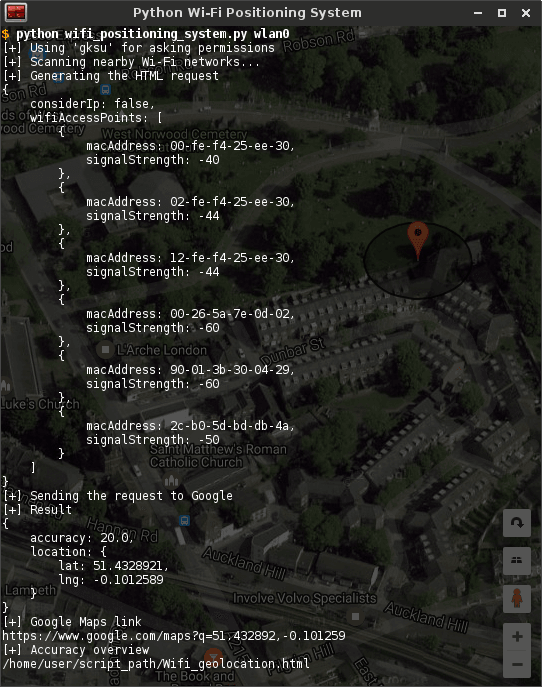
https://developers.google.com/maps/documentation/geolocation/introScreenshot from a previous version (without argparse):

Installation on GNU/Linux and OpenBSD ($: user, #: root):
On GNU/Linux, the script use the
iwcommand to gain access to the Wi-Fi peripheral.
On OpenBSD, it use theifconfigcommand to gain access to the Wi-Fi peripheral.
On Ubuntu distribution, it require the installation of the following dependencies:# apt-get install iwOn Gentoo distribution, it require the installation of the following dependencies:
# emerge -av net-wireless/iwThe full git repository is at: https://github.com/initbrain/Python-Wi-Fi-Positioning-System
Get it using the following command:$ git clone https://github.com/initbrain/Python-Wi-Fi-Positioning-SystemAnd proceed to final steps.
On GNU/Linux, to use the tool, launch it withrootprivileges:$ cd Python-Wi-Fi-Positioning-System/ $ python wifi_positioning_system.py -h # python wifi_positioning_system.py --api-key <GOOGLE_API_KEY> -i <WIFI_INTERFACE> --verbose --json-prettify --with-overview --map-type <ROADMAP|SATELLITE|HYBRID|TERRAIN>Installation on Mac OS X:
On Mac OS X, it use
airportto gain access to the Wi-Fi peripheral.
Get it using...% TODOAnd proceed to final steps.
% python wifi_positioning_system.py --api-key <GOOGLE_API_KEY> --verbose --json-prettify --with-overview --map-type <ROADMAP|SATELLITE|HYBRID|TERRAIN>Usage:
On GNU/Linux and OpenBSD, a Wi-Fi interface name is required to scan with
iwandifconfigcommands:usage: wifi_positioning_system.py [-h] [-V] [-L] [-v] [-k API_KEY] [-p] [-o] [-m {ROADMAP,SATELLITE,HYBRID,TERRAIN}] (-i WIFI_INTERFACE | --demo) optional arguments: -h, --help show this help message and exit -V, --version show program's version number and exit -L, --license show program's license details and exit -v, --verbose enable verbose messages -k API_KEY, --api-key API_KEY Google Geolocation API key (could be hardcoded) -p, --json-prettify prettify JSON output -o, --with-overview accuracy overview file generation -m {ROADMAP,SATELLITE,HYBRID,TERRAIN}, --map-type {ROADMAP,SATELLITE,HYBRID,TERRAIN} accuracy overview map type required arguments: -i WIFI_INTERFACE specify Wi-Fi scan interface --demo demo mode - West Norwood (London) additional informations: ROADMAP displays the default road map view SATELLITE displays Google Earth satellite images HYBRID displays a mixture of normal and satellite views (this is the default map type) TERRAIN displays a physical map based on terrain informationOn Mac OS X, there is no need of a Wi-Fi interface name to launch a scan with
airport:usage: wifi_positioning_system.py [-h] [-V] [-L] [-v] [-k API_KEY] [-p] [-o] [-m {ROADMAP,SATELLITE,HYBRID,TERRAIN}] [--demo] optional arguments: -h, --help show this help message and exit -V, --version show program's version number and exit -L, --license show program's license details and exit -v, --verbose enable verbose messages -k API_KEY, --api-key API_KEY Google Geolocation API key (could be hardcoded) -p, --json-prettify prettify JSON output -o, --with-overview accuracy overview file generation -m {ROADMAP,SATELLITE,HYBRID,TERRAIN}, --map-type {ROADMAP,SATELLITE,HYBRID,TERRAIN} accuracy overview map type --demo demo mode - West Norwood (London) additional informations: ROADMAP displays the default road map view SATELLITE displays Google Earth satellite images HYBRID displays a mixture of normal and satellite views (this is the default map type) TERRAIN displays a physical map based on terrain informationContributors (ext-repo):
Initial publication on Twitter
2012-06-25: modified to run on OS X - James Armitage (@armitagej)
2012-06-26: modified to process in python - Dan Gleebits (@DGleebits)
2012-10-01: modified to parse the xml output of airport - Vincent Ohprecio (@BigsnarfDude)
2017-01-03: modified to work with the new Google Geolocation API - Giovanni Angoli (@juzam)
2017-01-06: merging all modifications - Julien Deudon (@initbrain)
2017-01-07: modified to support new permissions assignement methods - Julien Deudon (@initbrain)
2017-01-08: source code reorganization - Julien Deudon (@initbrain)
2017-01-15: OpenBSD port - Geoffrey Robert (@mks10110)