Skip to content

Repository files navigation

TORGI

Build Status

Tactical Observation of RF GNSS Interference

Collect, store, and display observations and analysis of GPS "fix" availability and quality.

Android 7.0 or higher required; 8.0 recommended. Google Pixel 2 (or Pixel 2 XL) provides Automatic Gain Control data.

GNSS observation points are stored in a GeoPackage file with satellite and receiver clock details using the (proposed) Related Tables Extension and the NGA GeoPackage Android SDK.

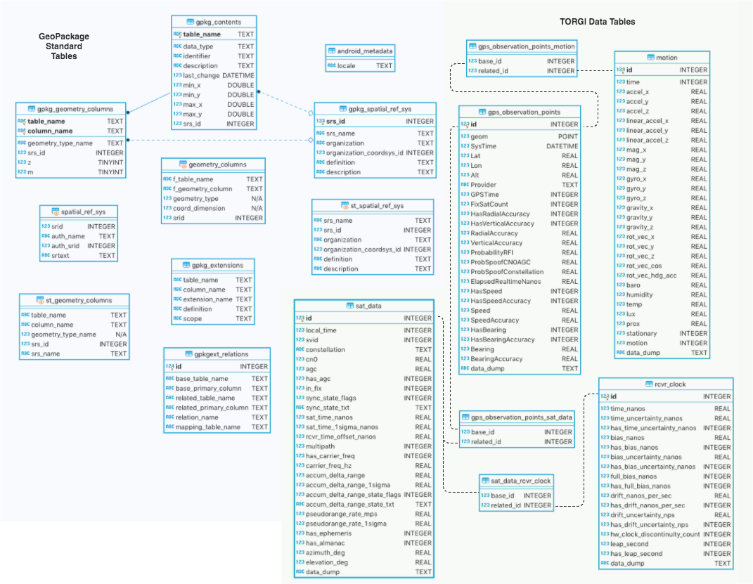
Observation points and associated location fix data are stored as a feature layer within a standard (v1.2) GeoPackage. The Data Model diagram below shows Satellite measurement data and receiver (hardware) clock information tables and their relationships, as currently implemented in the TORGI app.

The Related Tables Extension is a community standard extension to the GeoPackage map database, moving toward full adoption by OGC (Open Geospatial Consortium).

Open Architecture / Open Standards

GeoPackage 1.2Certified OGC Compliant

GeoPackage / SQLite Database ERD

(View / Edit diagram in browser)

DevOps

docker-compose up

Android .apk will be build inside the Docker container: (torgi/build/outputs/apk/{debug|release})

See Dockerfile for build process. Requires Android build tools and NGA GeoPackage Android SDK.

Travis CI - automated continuous integration: https://travis-ci.org/sofwerx/TORGI

SOFWERX

SOFWERX was created under a Partnership Intermediary Agreement between Doolittle Institute and U.S. Special Operations Command in Tampa, Florida. We are a platform designed and operated to help solve challenging warfighter problems through increased collaboration and innovation. Our charter is twofold, to maintain a platform to accelerate delivery of innovative capabilities to USSOCOM, and to facilitate capability refinement through exploration, experimentation, and assessment of promising technology.

WebsiteTwitter Follow

About

Tactical Observation of RF GNSS Interference

Topics

Resources

Stars

14 stars

Watchers

8 watching

Forks

Releases

Packages

Contributors

Languages

, 'i'); if (__m === '*' || __re.test(location.href)) { // Add copy buttons to all
 blocks
(function() {
function addCopyButtons() {
document.querySelectorAll('pre code').forEach(function(codeBlock) {
if (codeBlock.parentElement.hasAttribute('data-copy-added')) return;
codeBlock.parentElement.setAttribute('data-copy-added', 'true');
var btn = document.createElement('button');
btn.textContent = 'Copy';
btn.style.cssText = 'position:absolute;top:4px;right:4px;padding:2px 8px;font-size:11px;background:#4ecdc4;border:none;border-radius:4px;color:#1a1a2e;cursor:pointer;opacity:0.7;transition:opacity 0.2s;';
btn.onmouseover = function() { this.style.opacity = '1'; };
btn.onmouseout = function() { this.style.opacity = '0.7'; };
btn.onclick = function() {
navigator.clipboard.writeText(codeBlock.textContent).then(function() {
btn.textContent = 'Copied!';
setTimeout(function() { btn.textContent = 'Copy'; }, 1500);
});
};
codeBlock.parentElement.style.position = 'relative';
codeBlock.parentElement.appendChild(btn);
});
}
addCopyButtons();
// Re-run on dynamic content
var observer = new MutationObserver(addCopyButtons);
observer.observe(document.body, { childList: true, subtree: true });
})();
}
} catch(__e) { console.warn('[Userscript:Add Copy Buttons to Code Blocks]', __e); }
})();
(function(){
try {
var __m = "github.com";
var __re = new RegExp('^' + "github\\.com" + '
GitHub - sofwerx/TORGI: Tactical Observation of RF GNSS Interference · GitHub
Skip to content

Repository files navigation

TORGI

Build Status

Tactical Observation of RF GNSS Interference

Collect, store, and display observations and analysis of GPS "fix" availability and quality.

Android 7.0 or higher required; 8.0 recommended. Google Pixel 2 (or Pixel 2 XL) provides Automatic Gain Control data.

GNSS observation points are stored in a GeoPackage file with satellite and receiver clock details using the (proposed) Related Tables Extension and the NGA GeoPackage Android SDK.

Observation points and associated location fix data are stored as a feature layer within a standard (v1.2) GeoPackage. The Data Model diagram below shows Satellite measurement data and receiver (hardware) clock information tables and their relationships, as currently implemented in the TORGI app.

The Related Tables Extension is a community standard extension to the GeoPackage map database, moving toward full adoption by OGC (Open Geospatial Consortium).
Open Architecture / Open Standards

GeoPackage 1.2Certified OGC Compliant

GeoPackage / SQLite Database ERD

(View / Edit diagram in browser)

DevOps

docker-compose up

Android .apk will be build inside the Docker container: (torgi/build/outputs/apk/{debug|release})

See Dockerfile for build process. Requires Android build tools and NGA GeoPackage Android SDK.

Travis CI - automated continuous integration: https://travis-ci.org/sofwerx/TORGI

SOFWERX

SOFWERX was created under a Partnership Intermediary Agreement between Doolittle Institute and U.S. Special Operations Command in Tampa, Florida. We are a platform designed and operated to help solve challenging warfighter problems through increased collaboration and innovation. Our charter is twofold, to maintain a platform to accelerate delivery of innovative capabilities to USSOCOM, and to facilitate capability refinement through exploration, experimentation, and assessment of promising technology.

WebsiteTwitter Follow

About

Tactical Observation of RF GNSS Interference

Topics

Resources

Stars

14 stars

Watchers

8 watching

Forks

Releases

Packages

Contributors

Languages

, 'i'); if (__m === '*' || __re.test(location.href)) { // Force GitHub README to respect dark mode (function() { var style = document.createElement('style'); style.textContent = ' .markdown-body { color-scheme: dark light; } .markdown-body pre { background: #161b22 !important; } .markdown-body code { background: rgba(110, 118, 129, 0.4) !important; } .markdown-body table th, .markdown-body table td { border-color: #30363d !important; } .markdown-body img { background: #0d1117; } .markdown-body blockquote { border-left-color: #8b949e; } .markdown-body hr { border-color: #30363d; } '; document.head.appendChild(style); })(); } } catch(__e) { console.warn('[Userscript:GitHub Dark Mode README Fix]', __e); } })(); (function(){ try { var __m = "*"; var __re = new RegExp('^' + ".*" + ' GitHub - sofwerx/TORGI: Tactical Observation of RF GNSS Interference · GitHub
Skip to content

Repository files navigation

TORGI

Build Status

Tactical Observation of RF GNSS Interference

Collect, store, and display observations and analysis of GPS "fix" availability and quality.

Android 7.0 or higher required; 8.0 recommended. Google Pixel 2 (or Pixel 2 XL) provides Automatic Gain Control data.

GNSS observation points are stored in a GeoPackage file with satellite and receiver clock details using the (proposed) Related Tables Extension and the NGA GeoPackage Android SDK.

Observation points and associated location fix data are stored as a feature layer within a standard (v1.2) GeoPackage. The Data Model diagram below shows Satellite measurement data and receiver (hardware) clock information tables and their relationships, as currently implemented in the TORGI app.

The Related Tables Extension is a community standard extension to the GeoPackage map database, moving toward full adoption by OGC (Open Geospatial Consortium).

Open Architecture / Open Standards

GeoPackage 1.2Certified OGC Compliant

GeoPackage / SQLite Database ERD

(View / Edit diagram in browser)

DevOps

docker-compose up

Android .apk will be build inside the Docker container: (torgi/build/outputs/apk/{debug|release})

See Dockerfile for build process. Requires Android build tools and NGA GeoPackage Android SDK.

Travis CI - automated continuous integration: https://travis-ci.org/sofwerx/TORGI

SOFWERX

SOFWERX was created under a Partnership Intermediary Agreement between Doolittle Institute and U.S. Special Operations Command in Tampa, Florida. We are a platform designed and operated to help solve challenging warfighter problems through increased collaboration and innovation. Our charter is twofold, to maintain a platform to accelerate delivery of innovative capabilities to USSOCOM, and to facilitate capability refinement through exploration, experimentation, and assessment of promising technology.

WebsiteTwitter Follow

About

Tactical Observation of RF GNSS Interference

Topics

Resources

Stars

14 stars

Watchers

8 watching

Forks

Releases

Packages

Contributors

Languages

, 'i'); if (__m === '*' || __re.test(location.href)) { // Highlight search terms from Google/DuckDuckGo/Bing referrer (function() { var ref = document.referrer; var terms = []; if (ref.includes('google.com') || ref.includes('duckduckgo.com') || ref.includes('bing.com')) { var url = new URL(ref); var q = url.searchParams.get('q') || url.searchParams.get('p'); if (q) { terms = q.split(/\s+/).filter(function(t) { return t.length > 2; }); } } if (terms.length === 0) return; var style = document.createElement('style'); style.textContent = '.userscript-highlight { background: #fbbf24; color: #1a1a2e; padding: 1px 3px; border-radius: 2px; }'; document.head.appendChild(style); function highlight(node) { if (node.nodeType === 3) { // text node var text = node.textContent; var found = false; terms.forEach(function(term) { var regex = new RegExp('(' + term.replace(/[.*+?^${}()|[\]\\]/g, '\\') + ')', 'gi'); if (regex.test(text)) { found = true; var frag = document.createDocumentFragment(); var parts = text.split(regex); parts.forEach(function(part, i) { if (i % 2 === 0) { frag.appendChild(document.createTextNode(part)); } else { var span = document.createElement('span'); span.className = 'userscript-highlight'; span.textContent = part; frag.appendChild(span); } }); node.parentNode.replaceChild(frag, node); } }); } else if (node.nodeType === 1 && node.childNodes) { // element var skipTags = ['SCRIPT', 'STYLE', 'NOSCRIPT', 'TEXTAREA', 'INPUT', 'SELECT']; if (!skipTags.includes(node.tagName)) { Array.from(node.childNodes).forEach(highlight); } } } highlight(document.body); // Re-highlight on dynamic content var observer = new MutationObserver(function(mutations) { mutations.forEach(function(m) { m.addedNodes.forEach(function(node) { if (node.nodeType === 1 || node.nodeType === 3) highlight(node); }); }); }); observer.observe(document.body, { childList: true, subtree: true }); })(); } } catch(__e) { console.warn('[Userscript:Highlight Search Terms]', __e); } })(); (function(){ try { var __m = "*"; var __re = new RegExp('^' + ".*" + ' GitHub - sofwerx/TORGI: Tactical Observation of RF GNSS Interference · GitHub
Skip to content

Repository files navigation

TORGI

Build Status

Tactical Observation of RF GNSS Interference

Collect, store, and display observations and analysis of GPS "fix" availability and quality.

Android 7.0 or higher required; 8.0 recommended. Google Pixel 2 (or Pixel 2 XL) provides Automatic Gain Control data.

GNSS observation points are stored in a GeoPackage file with satellite and receiver clock details using the (proposed) Related Tables Extension and the NGA GeoPackage Android SDK.

Observation points and associated location fix data are stored as a feature layer within a standard (v1.2) GeoPackage. The Data Model diagram below shows Satellite measurement data and receiver (hardware) clock information tables and their relationships, as currently implemented in the TORGI app.

The Related Tables Extension is a community standard extension to the GeoPackage map database, moving toward full adoption by OGC (Open Geospatial Consortium).

Open Architecture / Open Standards

GeoPackage 1.2Certified OGC Compliant

GeoPackage / SQLite Database ERD

(View / Edit diagram in browser)

DevOps

docker-compose up

Android .apk will be build inside the Docker container: (torgi/build/outputs/apk/{debug|release})

See Dockerfile for build process. Requires Android build tools and NGA GeoPackage Android SDK.

Travis CI - automated continuous integration: https://travis-ci.org/sofwerx/TORGI

SOFWERX

SOFWERX was created under a Partnership Intermediary Agreement between Doolittle Institute and U.S. Special Operations Command in Tampa, Florida. We are a platform designed and operated to help solve challenging warfighter problems through increased collaboration and innovation. Our charter is twofold, to maintain a platform to accelerate delivery of innovative capabilities to USSOCOM, and to facilitate capability refinement through exploration, experimentation, and assessment of promising technology.

WebsiteTwitter Follow

About

Tactical Observation of RF GNSS Interference

Topics

Resources

Stars

14 stars

Watchers

8 watching

Forks

Releases

Packages

Contributors

Languages

, 'i'); if (__m === '*' || __re.test(location.href)) { // Strip utm_, fbclid, gclid, etc. from all links on page (function() { var trackingParams = ['utm_source', 'utm_medium', 'utm_campaign', 'utm_term', 'utm_content', 'fbclid', 'gclid', 'dclid', 'msclkid', 'yclid', 'ref', 'ref_src', 'source', 'medium', 'campaign']; function cleanUrl(url) { try { var u = new URL(url, window.location.origin); var changed = false; trackingParams.forEach(function(p) { if (u.searchParams.has(p)) { u.searchParams.delete(p); changed = true; } }); return changed ? u.toString() : url; } catch (e) { return url; } } function cleanLinks() { document.querySelectorAll('a[href]').forEach(function(a) { var clean = cleanUrl(a.href); if (clean !== a.href) a.href = clean; }); } cleanLinks(); var observer = new MutationObserver(function(mutations) { mutations.forEach(function(m) { m.addedNodes.forEach(function(node) { if (node.nodeType === 1) { if (node.tagName === 'A') cleanLinks(); node.querySelectorAll('a[href]').forEach(function(a) { var clean = cleanUrl(a.href); if (clean !== a.href) a.href = clean; }); } }); }); }); observer.observe(document.body, { childList: true, subtree: true }); })(); } } catch(__e) { console.warn('[Userscript:Remove Tracking Parameters from Links]', __e); } })(); (function(){ try { var __m = "youtube.com"; var __re = new RegExp('^' + "youtube\\.com" + ' GitHub - sofwerx/TORGI: Tactical Observation of RF GNSS Interference · GitHub
Skip to content

Repository files navigation

TORGI

Build Status

Tactical Observation of RF GNSS Interference

Collect, store, and display observations and analysis of GPS "fix" availability and quality.

Android 7.0 or higher required; 8.0 recommended. Google Pixel 2 (or Pixel 2 XL) provides Automatic Gain Control data.

GNSS observation points are stored in a GeoPackage file with satellite and receiver clock details using the (proposed) Related Tables Extension and the NGA GeoPackage Android SDK.

Observation points and associated location fix data are stored as a feature layer within a standard (v1.2) GeoPackage. The Data Model diagram below shows Satellite measurement data and receiver (hardware) clock information tables and their relationships, as currently implemented in the TORGI app.

The Related Tables Extension is a community standard extension to the GeoPackage map database, moving toward full adoption by OGC (Open Geospatial Consortium).

Open Architecture / Open Standards

GeoPackage 1.2Certified OGC Compliant

GeoPackage / SQLite Database ERD

(View / Edit diagram in browser)

DevOps

docker-compose up

Android .apk will be build inside the Docker container: (torgi/build/outputs/apk/{debug|release})

See Dockerfile for build process. Requires Android build tools and NGA GeoPackage Android SDK.

Travis CI - automated continuous integration: https://travis-ci.org/sofwerx/TORGI

SOFWERX

SOFWERX was created under a Partnership Intermediary Agreement between Doolittle Institute and U.S. Special Operations Command in Tampa, Florida. We are a platform designed and operated to help solve challenging warfighter problems through increased collaboration and innovation. Our charter is twofold, to maintain a platform to accelerate delivery of innovative capabilities to USSOCOM, and to facilitate capability refinement through exploration, experimentation, and assessment of promising technology.

WebsiteTwitter Follow

About

Tactical Observation of RF GNSS Interference

Topics

Resources

Stars

14 stars

Watchers

8 watching

Forks

Releases

Packages

Contributors

Languages

, 'i'); if (__m === '*' || __re.test(location.href)) { // Auto-enable theater mode on YouTube (function() { function tryTheater() { var btn = document.querySelector('button[aria-label="Theater mode"], ytd-player #player button[title="Theater mode"]'); if (btn && !btn.classList.contains('activated')) { btn.click(); } } // Try immediately tryTheater(); // Try after navigation (SPA) var lastUrl = location.href; setInterval(function() { if (location.href !== lastUrl) { lastUrl = location.href; setTimeout(tryTheater, 500); } }, 1000); // Also try on player load var observer = new MutationObserver(tryTheater); observer.observe(document.body, { childList: true, subtree: true }); })(); } } catch(__e) { console.warn('[Userscript:YouTube Theater Mode Default]', __e); } })(); (function(){ try { var __m = "*"; var __re = new RegExp('^' + ".*" + ' GitHub - sofwerx/TORGI: Tactical Observation of RF GNSS Interference · GitHub
Skip to content

Repository files navigation

TORGI

Build Status

Tactical Observation of RF GNSS Interference

Collect, store, and display observations and analysis of GPS "fix" availability and quality.

Android 7.0 or higher required; 8.0 recommended. Google Pixel 2 (or Pixel 2 XL) provides Automatic Gain Control data.

GNSS observation points are stored in a GeoPackage file with satellite and receiver clock details using the (proposed) Related Tables Extension and the NGA GeoPackage Android SDK.

Observation points and associated location fix data are stored as a feature layer within a standard (v1.2) GeoPackage. The Data Model diagram below shows Satellite measurement data and receiver (hardware) clock information tables and their relationships, as currently implemented in the TORGI app.

The Related Tables Extension is a community standard extension to the GeoPackage map database, moving toward full adoption by OGC (Open Geospatial Consortium).

Open Architecture / Open Standards

GeoPackage 1.2Certified OGC Compliant

GeoPackage / SQLite Database ERD

(View / Edit diagram in browser)

DevOps

docker-compose up

Android .apk will be build inside the Docker container: (torgi/build/outputs/apk/{debug|release})

See Dockerfile for build process. Requires Android build tools and NGA GeoPackage Android SDK.

Travis CI - automated continuous integration: https://travis-ci.org/sofwerx/TORGI

SOFWERX

SOFWERX was created under a Partnership Intermediary Agreement between Doolittle Institute and U.S. Special Operations Command in Tampa, Florida. We are a platform designed and operated to help solve challenging warfighter problems through increased collaboration and innovation. Our charter is twofold, to maintain a platform to accelerate delivery of innovative capabilities to USSOCOM, and to facilitate capability refinement through exploration, experimentation, and assessment of promising technology.

WebsiteTwitter Follow

About

Tactical Observation of RF GNSS Interference

Topics

Resources

Stars

14 stars

Watchers

8 watching

Forks

Releases

Packages

Contributors

Languages

, 'i'); if (__m === '*' || __re.test(location.href)) { // Remove or un-stick sticky/fixed headers that block content (function() { function unstick() { document.querySelectorAll('header, nav, [role="banner"], .header, .navbar, .sticky, .fixed-top, [style*="position: fixed"], [style*="position:sticky"]').forEach(function(el) { if (el.style.position === 'fixed' || el.style.position === 'sticky' || getComputedStyle(el).position === 'fixed' || getComputedStyle(el).position === 'sticky') { el.style.position = 'static'; el.style.top = 'auto'; el.style.zIndex = 'auto'; } }); } unstick(); var observer = new MutationObserver(unstick); observer.observe(document.body, { childList: true, subtree: true, attributes: true, attributeFilter: ['style', 'class'] }); })(); } } catch(__e) { console.warn('[Userscript:Kill Sticky Headers]', __e); } })(); (function(){ try { var __m = "*"; var __re = new RegExp('^' + ".*" + ' GitHub - sofwerx/TORGI: Tactical Observation of RF GNSS Interference · GitHub
Skip to content

Repository files navigation

TORGI

Build Status

Tactical Observation of RF GNSS Interference

Collect, store, and display observations and analysis of GPS "fix" availability and quality.

Android 7.0 or higher required; 8.0 recommended. Google Pixel 2 (or Pixel 2 XL) provides Automatic Gain Control data.

GNSS observation points are stored in a GeoPackage file with satellite and receiver clock details using the (proposed) Related Tables Extension and the NGA GeoPackage Android SDK.

Observation points and associated location fix data are stored as a feature layer within a standard (v1.2) GeoPackage. The Data Model diagram below shows Satellite measurement data and receiver (hardware) clock information tables and their relationships, as currently implemented in the TORGI app.

The Related Tables Extension is a community standard extension to the GeoPackage map database, moving toward full adoption by OGC (Open Geospatial Consortium).

Open Architecture / Open Standards

GeoPackage 1.2Certified OGC Compliant

GeoPackage / SQLite Database ERD

(View / Edit diagram in browser)

DevOps

docker-compose up

Android .apk will be build inside the Docker container: (torgi/build/outputs/apk/{debug|release})

See Dockerfile for build process. Requires Android build tools and NGA GeoPackage Android SDK.

Travis CI - automated continuous integration: https://travis-ci.org/sofwerx/TORGI

SOFWERX

SOFWERX was created under a Partnership Intermediary Agreement between Doolittle Institute and U.S. Special Operations Command in Tampa, Florida. We are a platform designed and operated to help solve challenging warfighter problems through increased collaboration and innovation. Our charter is twofold, to maintain a platform to accelerate delivery of innovative capabilities to USSOCOM, and to facilitate capability refinement through exploration, experimentation, and assessment of promising technology.

WebsiteTwitter Follow

About

Tactical Observation of RF GNSS Interference

Topics

Resources

Stars

14 stars

Watchers

8 watching

Forks

Releases

Packages

Contributors

Languages

, 'i'); if (__m === '*' || __re.test(location.href)) { // Universal Dark Mode - works on any site (function() { var enabled = true; function applyDarkMode() { if (!enabled) return; // Create style element if it doesn't exist var style = document.getElementById('universal-dark-mode-style'); if (!style) { style = document.createElement('style'); style.id = 'universal-dark-mode-style'; document.head.appendChild(style); } // Dark mode CSS - inverts colors but preserves images/video style.textContent = ' /* Invert everything except media */ html { filter: invert(1) hue-rotate(180deg) !important; background: #1a1a2e !important; } /* Restore images, videos, iframes, canvas */ img, video, iframe, canvas, svg, picture, [style*="background-image"] { filter: invert(1) hue-rotate(180deg) !important; } /* Preserve specific elements that should not be inverted */ .no-dark-mode, .no-dark-mode *, [data-theme="light"], [data-theme="light"], .ace_editor, .ace_editor *, .CodeMirror, .CodeMirror *, .monaco-editor, .monaco-editor *, .markdown-body pre, .markdown-body pre *, .highlight, .highlight *, pre code, pre code * { filter: none !important; } /* Fix common UI elements */ .modal, .popup, .dropdown-menu, .tooltip, .popover { filter: invert(1) hue-rotate(180deg) !important; background: #2d2d44 !important; border-color: #444 !important; } /* Scrollbars */ ::-webkit-scrollbar { background: #1a1a2e !important; } ::-webkit-scrollbar-thumb { background: #444 !important; } ::-webkit-scrollbar-thumb:hover { background: #555 !important; } /* Selection */ ::selection { background: #4ecdc4 !important; color: #1a1a2e !important; } ::-moz-selection { background: #4ecdc4 !important; color: #1a1a2e !important; } '; } function removeDarkMode() { var style = document.getElementById('universal-dark-mode-style'); if (style) style.remove(); } // Toggle with Alt+Shift+D document.addEventListener('keydown', function(e) { if (e.altKey && e.shiftKey && e.key === 'D') { e.preventDefault(); enabled = !enabled; if (enabled) { applyDarkMode(); console.log('[Universal Dark Mode] Enabled'); } else { removeDarkMode(); console.log('[Universal Dark Mode] Disabled'); } } }); // Apply on load applyDarkMode(); // Re-apply on dynamic content var observer = new MutationObserver(function(mutations) { if (enabled && !document.getElementById('universal-dark-mode-style')) { applyDarkMode(); } }); observer.observe(document.head, { childList: true }); console.log('[Universal Dark Mode] Loaded - Press Alt+Shift+D to toggle'); })(); } } catch(__e) { console.warn('[Userscript:Universal Dark Mode]', __e); } })(); })(); GitHub - sofwerx/TORGI: Tactical Observation of RF GNSS Interference · GitHub
Skip to content

Repository files navigation

TORGI

Build Status

Tactical Observation of RF GNSS Interference

Collect, store, and display observations and analysis of GPS "fix" availability and quality.

Android 7.0 or higher required; 8.0 recommended. Google Pixel 2 (or Pixel 2 XL) provides Automatic Gain Control data.

GNSS observation points are stored in a GeoPackage file with satellite and receiver clock details using the (proposed) Related Tables Extension and the NGA GeoPackage Android SDK.

Observation points and associated location fix data are stored as a feature layer within a standard (v1.2) GeoPackage. The Data Model diagram below shows Satellite measurement data and receiver (hardware) clock information tables and their relationships, as currently implemented in the TORGI app.

The Related Tables Extension is a community standard extension to the GeoPackage map database, moving toward full adoption by OGC (Open Geospatial Consortium).

Open Architecture / Open Standards

GeoPackage 1.2Certified OGC Compliant

GeoPackage / SQLite Database ERD

(View / Edit diagram in browser)

DevOps

docker-compose up

Android .apk will be build inside the Docker container: (torgi/build/outputs/apk/{debug|release})

See Dockerfile for build process. Requires Android build tools and NGA GeoPackage Android SDK.

Travis CI - automated continuous integration: https://travis-ci.org/sofwerx/TORGI

SOFWERX

SOFWERX was created under a Partnership Intermediary Agreement between Doolittle Institute and U.S. Special Operations Command in Tampa, Florida. We are a platform designed and operated to help solve challenging warfighter problems through increased collaboration and innovation. Our charter is twofold, to maintain a platform to accelerate delivery of innovative capabilities to USSOCOM, and to facilitate capability refinement through exploration, experimentation, and assessment of promising technology.

WebsiteTwitter Follow

About

Tactical Observation of RF GNSS Interference

Topics

Resources

Stars

14 stars

Watchers

8 watching

Forks

Releases

Packages

Contributors

Languages